 An Australian project to develop a space-based augmentation system (SBAS) that promises navigational accuracy to less than 10 centimetres is “well underway”, according to Lockheed Martin, one of three industry participants in a two-year Australian Government-led trial.
“We are undertaking a two-year testbed that will dramatically improve the accuracy of navigation systems. That program started in February, it is well and truly underway,” Rod Drury, Lockheed Martin Australia’s managing director for space, told media in Canberra on Wednesday.
The two-year, $12 million project to develop a “second generation” SBAS in Australia was announced in February this year and involves industry participation from Lockheed Martin, GMV of Spain and Inmarsat. Led by Geoscience Australia, the project has also received New Zealand Government funding, while other countries in the region have shown strong interest in participating in the trial.
“The project was initially sponsored by the Australian Government, with Geoscience Australia the lead agency, while the New Zealand Government has also joined the demonstration program,” Drury said.
“And I can share with you that we are currently engaged with a number of other countries in the region.”
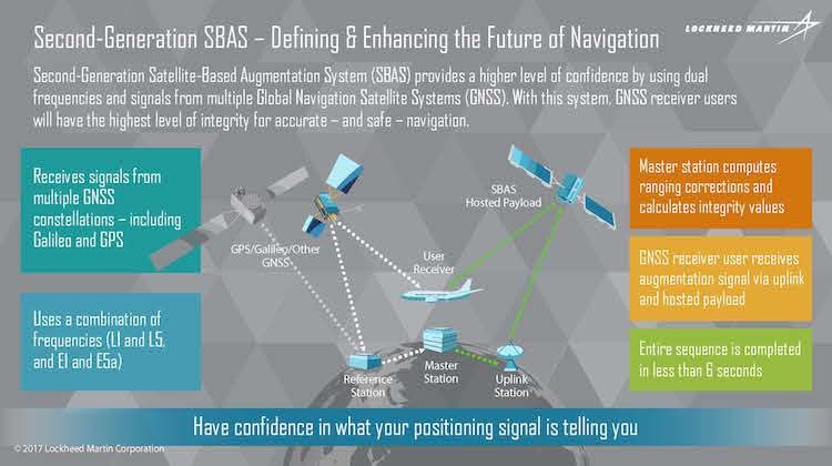
Under the trial GMV has installed an SBAS testbed master station, which collects data from Geoscience Australia-operated reference stations and generates augmentation messages that corrects the accuracy of global navigation satellite system (GNSS) positional information.
That data is then sent via a Lockheed Martin uplink antenna at Uralla, New South Wales, to an Inmarsat geostationary earth orbit satellite. A receiver on a ground-based vehicle or aircraft then processes that corrected positional information.
Drury noted that without augmentation GNSS systems such as the US GPS constellation and the European Gallileo system offers navigational accuracy of around 10 metres in the horizontal plane.
“We’ve taken that accuracy from 10 metres down to a metre or two, and ultimately the horizontal accuracy will end up in the range of centimetres, somewhere around five to 10 centimetre accuracy,” Drury said.
Accuracy in the vertical will be in the “same magnitude” but varies due to ionospheric conditions, Drury said, but “the closer you get to the equator the more challenge you have with the ionosphere”.
The promised accuracy of SBAS has a number of applications in aviation, and not just the promise of cost-effective highly-accurate precision approaches for airports large and small, but also increasing airport capacity because “you can stack aircraft a lot closer because you have more confidence in the precision and the accuracy that they’re receiving,” Drury noted.
But Airservices Australia is just one of a number of Australian Government agencies observing the trial, with SBAS seen to have applications across the agriculture, construction, maritime, mining, road and rail industries.
“What’s been really exciting from my perspective is the number of small to medium enterprises in Australia that are taking advantage of that technological step and are generating apps or new capabilities as a result of it,” Drury noted.
“Some of the companies that are engaging with us are taking this in directions we hadn’t even thought of.”
In its mature form the system would comprise “probably two or three” purpose-built ground stations across Australia, and a master control station. The Australian-developed SBAS promises not only greater accuracy than existing SBAS applications – the US Wide Area Augmentation System (or WAAS) typically provides better than one metre accuracy – but is a technology that could be easily implemented worldwide.
“Things all working well, the program in two years goes to maturity and rolls out to production, then we would seek to take what’s currently a regional capability and roll that out around the globe,” Drury said.
Different business models for using the SBAS are still being studied, Drury said.


